TRANSFORMATIONAL

CONVERGENT

DIVERGENT
 |
Plates? What Plates?
12 05 2008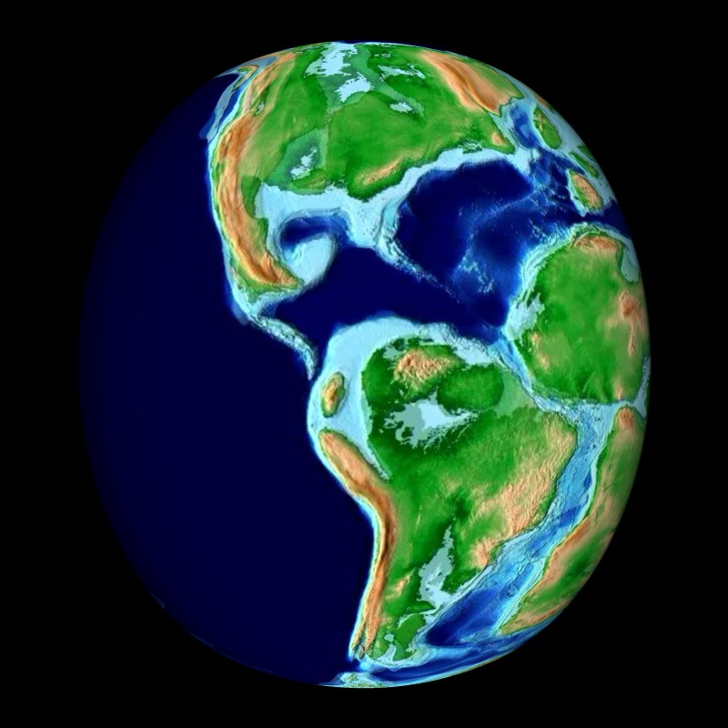
The basic idea of plate tectonics is that the Earth is made up of several large, moving pieces of solid rock, on the ocean and on continents. They are plates floating on softer like rock. The plates are in constant motion and sometimes run into one another, this is called a collision, or they slide along, over or under one another. Their motion, and collisions can explain several geological events including earthquakes. It also explains the presence of faults on many continents, where two plates collide, including the San Andreas fault in California.
Under the ocean, the plates explain why there is major seismic energy in the Pacific Ocean and how deep ocean trenches and large fracture zones and rifts in the ocean floor occur. Plates also give reason to associate volcanoes and large mountain belts like the Andes. Plates are the reason mountain belts form, from the pushing of plates and vast spreading and colliding of plate tectonics..
Why are plates so important to understand? How do they contribute to our overall understanding of Earth and seismic motion?
Here is a great article about Plate Tectonics with great illustrations and explanations about faults, environments and locations of plates on Earth. Check it out!


PANGAEA

During the last decades the capability and precision of tools used to sample and analyze our earth have increased exponentially - with an analogous increase in the resulting data output. At the same time, the information technology has made significant advances, which allow storage, distribution and processing of a nearly unlimited amount of data. Not concurrent with this progress is, however, the development of a related culture for a sustainable delivery of scientific data to future research. It is no longer feasible to publish data in publications. In spite of this, the bibliographic archiving of primary data from projects and publications is still not an integral part of the scientific workflow and thus most of the data are getting lost while hardware and software are changing quickly. Today this is considered to be one of the most crucial deficiencies in science. Various institutions, foundations and international organizations like the OECD are currently formulating recommendations for an improved data archiving.
Thanks to the support of AWI’s computer centre, scientists at AWI and MARUM after many years of work were able to build a sustainable information system. PANGAEA®, as a universal data library, is also a publication system and allows integration of data in the established process of scientific publications. Thus Pangaea is an information system, which encourages scientists to freely archive their data in an open access environment.

Monday, November 10, 2008
The thermosphere is the layer of the earth's atmosphere directly above the mesosphere and directly below the exosphere. Within this layer, ultraviolet radiation causes ionization.
The thermosphere, named from the Greek θερμός (thermos) for heat, begins about 90 km above the earth.[1] At these high altitudes, the residual atmospheric gases sort into strata according to molecular mass (see turbosphere). Thermospheric temperatures increase with altitude due to absorption of highly energetic solar radiation by the small amount of residual oxygen still present. Temperatures are highly dependent on solar activity, and can rise to 1,500°C. Radiation causes the atmosphere particles in this layer to become electrically charged (see ionosphere), enabling radio waves to bounce off and be received beyond the horizon. At the exosphere, beginning at 500 to 2,000 km above the earth's surface, the atmosphere mixes into space.
The few particles of gas in this area can reach 2,500°C (4532°F) during the day. Even though the temperature is so high, one would not feel warm in the thermosphere, because it is so near vacuum that there is not enough contact with the few atoms of gas to transfer much heat. A normal thermometer would read significantly below 0°C.
The upper region of this atmospheric layer is called the ionosphere.
The dynamics of the lower thermosphere (below about 120 km) are dominated by atmospheric tide, which is driven, in part, by the very significant diurnal heating. The atmospheric tide dissipates above this level since molecular concentrations do not support the coherent motion needed for fluid flow.
The International Space Station has a stable orbit within the upper part of the thermosphere, between 320 and 380 kilometers. The auroras also occur in the thermosphere.
The exosphere is the uppermost layer of the atmosphere. On Earth, its lower boundary at the edge of the thermosphere is estimated to be 500 km to 1000 km above the Earth's surface, and its upper boundary at about 10,000 km. It is only from the exosphere that atmospheric gases, atoms, and molecules can, to any appreciable extent, escape into space. The main gases within the exosphere are the lightest gases, mainly hydrogen, with some helium, carbon dioxide, and atomic oxygen near the exobase. The exosphere is the last layer before space.
Exobase, also called the critical level, the lowest altitude of the exosphere, is defined in one of two ways:
- The height above which there are the negligible atomic collisions between the particles and
- The height above which constituent atoms are on purely ballistic trajectories.


No comments:
Post a Comment